How to Import an Excel or CSV File to a Map
Turn a spreadsheet into a map: import Excel, CSV, addresses, GeoJSON, KML, GPX or Shapefiles, pick the location columns and fix messy data. Free.
Updated · by the mapbow team
Most location data starts life in a spreadsheet: a list of stores, customers, job sites, survey points or event venues. Putting it on a map shows what the rows cannot – clusters, gaps, who is closest to whom. In mapbow you can import an Excel or CSV file, paste rows straight from a spreadsheet, or type a list of addresses, and every row becomes a place on the map with all of its columns kept. Your own data is free and unlimited.
Import a spreadsheet step by step
- Open the Import panel. Click Import on the left rail (or Import your own data at the top of Add data). Your own data is free and unlimited - it never uses one of the map's free data-layer slots.
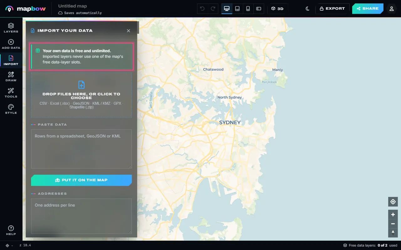
Step 1 The Import panel: files, pasted rows and addresses, all free. - Choose your Excel or CSV file. Drop the file on the panel or the map, or click the box to choose it. Excel (.xlsx), CSV, TSV, GeoJSON, KML, KMZ, GPX and zipped Shapefiles all work. The first rows are shown so you can check them.
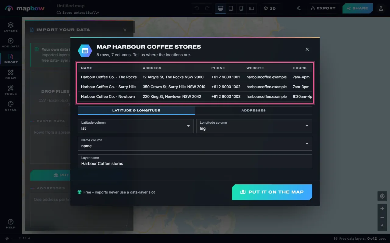
Step 2 An Excel file of eight stores, read in the browser - nothing is uploaded. - Tell mapbow where the locations are. Columns called lat / lng, latitude / longitude or x / y are picked for you. Use Addresses for a column of street addresses, or WKT geometry for lines and areas written as text. Check the Name column and the Layer name, then press Put it on the map.
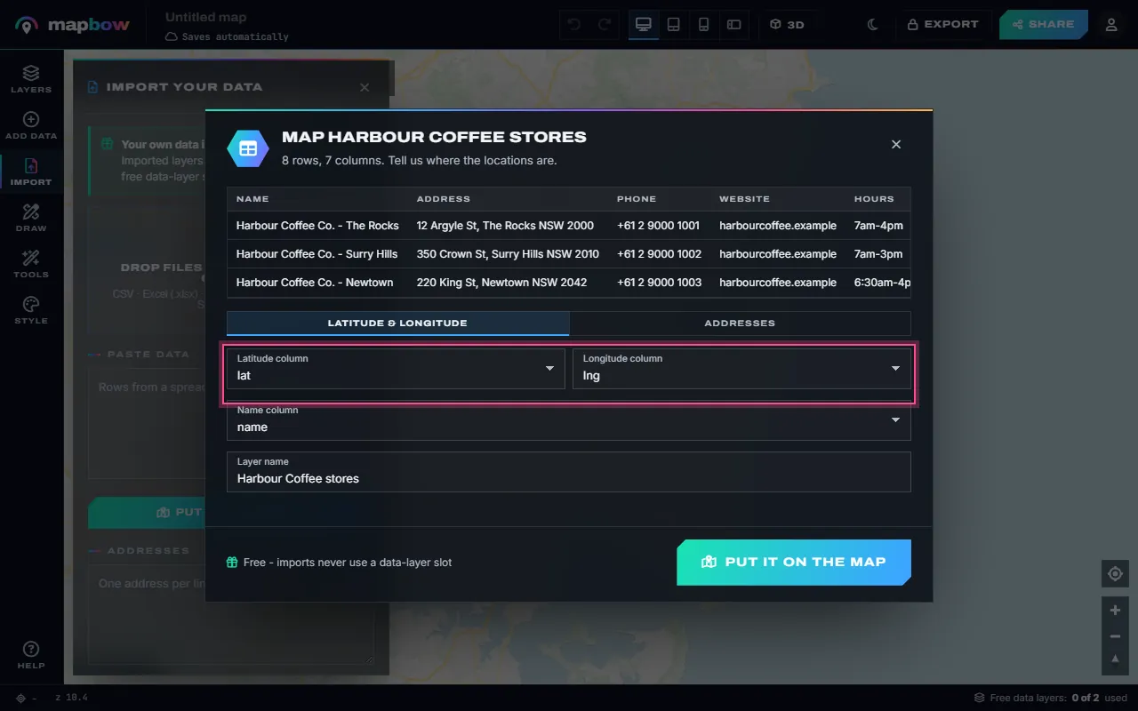
Step 3 The latitude, longitude and name columns, found automatically. - Your layer is on the map. Every row is now a pin, every column a field you can label, filter, colour and show in popups. The layer list marks it Imported · free.
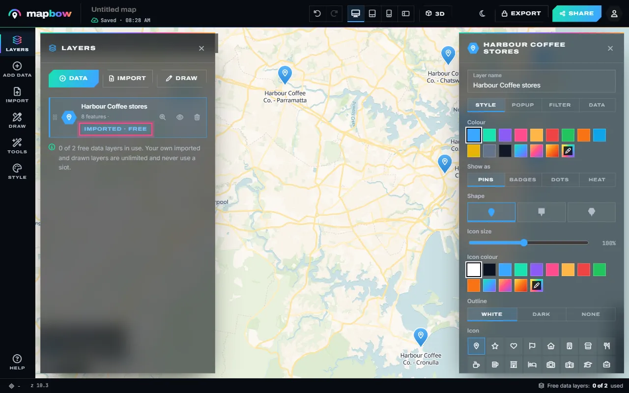
Step 4 Imported layers are marked free - the free-layer meter does not move. - Only addresses? Type them. Paste one address per line under Addresses and press Find and pin them. Up to 250 addresses are found, about one a second.
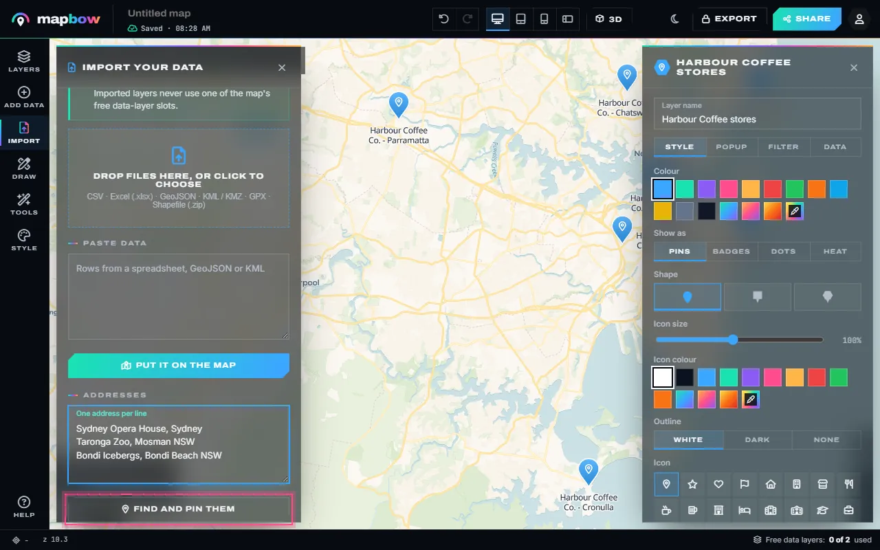
Step 5 Three addresses, ready to be found and pinned. - Addresses become pins. Each address is looked up and pinned with its full address kept as a field. You are told how many were found, so you can fix and re-add the rest.
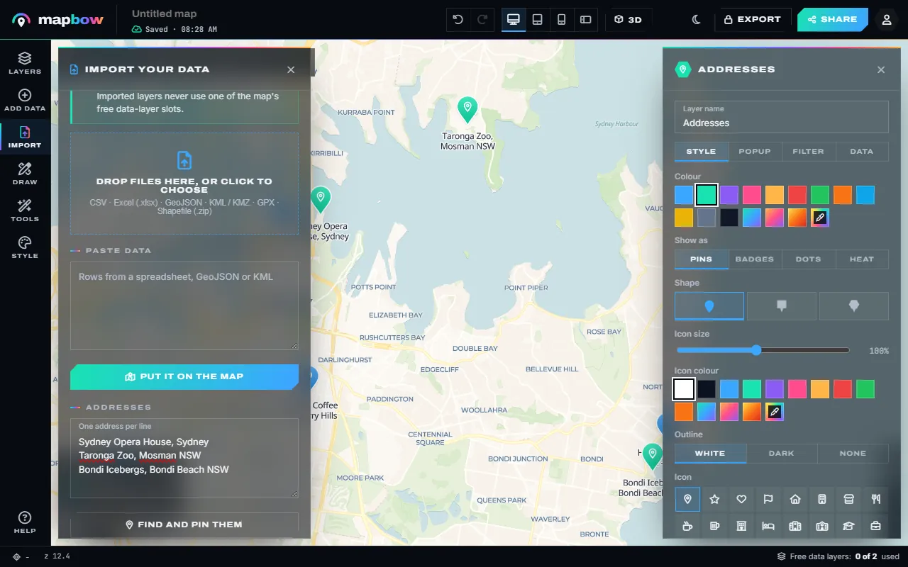
Step 6 The addresses, found and pinned.
Not sure what a file should look like? Use Download a sample CSV in the Import panel, open it in Excel and replace the rows with your own.
Every way to get data in
| You have | Do this |
|---|---|
| An Excel workbook (.xlsx) | Drop the file. The first sheet is read, so move your table to the first sheet. Old .xls files need saving as .xlsx or CSV first. |
| A CSV, TSV or TXT file | Drop the file. Commas and tabs both work. |
| Rows open in a spreadsheet | Copy them (with the header row) and paste into Paste data, or press Ctrl+V on the map. Headerless "lat, lng, name" rows also work. |
| A list of addresses | Paste one per line into Addresses, or pick Addresses in the column dialog for a file. |
| GeoJSON, KML, KMZ or GPX | Drop the file, or paste GeoJSON or KML text into Paste data. Lines and areas come in as they are. |
| A Shapefile | Zip the .shp and .dbf (and their sister files) together and drop the .zip. WGS 84 or Web Mercator coordinates are read. |
| Shapes as text (WKT) | A column of POINT (...), LINESTRING (...) or POLYGON (...) text - the column dialog offers WKT geometry. |
For the differences between these formats, see map file formats explained. You can also drop a file anywhere on the map, not just on the panel.
How columns are detected
The column dialog shows the first rows and how many rows and columns were found. It looks for coordinate columns named lat, latitude or y and lng, lon, long, longitude or x (spaces, dashes and capitals do not matter). If there are none but a column is called something like address or location, it starts on Addresses. A name column (name, title, store, company and similar) becomes each place's title. You can override every choice from the drop-down lists.
Every other column is kept as a field. Numbers are stored as numbers, so you can later colour by them, filter "greater than", or see their average in Statistics.
Tips for clean data
- One header row, nothing above it. The first row must hold the column names. Delete titles, logos, merged cells and blank rows above the table.
- Use decimal degrees. Coordinates like
-33.8568, 151.2153work. Degrees-minutes-seconds such as33°51'Sdo not - convert them first. A decimal comma (-33,8568) is fine. - Watch for swapped latitude and longitude. Latitude is north–south (−90 to 90), longitude east–west (−180 to 180). If your Sydney stores land in the ocean or Antarctica, the columns are the wrong way round - swap them in the column dialog. Rows with no valid location are skipped and you are told how many.
- Write full addresses. "12 Argyle St, The Rocks NSW 2000, Australia" is found far more reliably than "12 Argyle St". Include the town, postcode and country; drop unit numbers and notes like "rear entrance".
- Over 250 addresses? Address lookup stops at 250 per import. For bigger lists, add latitude and longitude columns to your spreadsheet, or import in batches.
- Keep contact columns simple. Columns named website and phone power the Website and Call buttons in popups.
Spotted a mistake after importing? Open the layer's Data tab and Open the table: on your own layers you can edit any cell, add a column or delete rows without going back to Excel.
Why importing is free and unlimited
Each map has two free slots for mapbow's ready-made data layers (hospitals, schools, postcodes and so on). Your own data is different: imported layers never use a slot, however many you add or however many rows they hold. The free-layer meter does not move. Files are read in your browser, and the map saves automatically, with no sign-up needed to start. Sharing needs a free account, and exports (CSV, GeoJSON, KML, Shapefile and more) unlock with any purchase.
What to do next
- Style the pins, cluster nearby points and add labels – see how to make a map with multiple locations.
- Choose what each popup shows with custom popups.
- See density with a heat map or a hex bin map.
- Put it on your site as a store locator.
Frequently asked questions
Can I put an Excel spreadsheet on a map for free?
Yes. Importing Excel, CSV and other files is free and unlimited, and imported layers never use one of the map's free data-layer slots.
My spreadsheet only has addresses. Will it work?
Yes. Choose Addresses in the column dialog, or paste the addresses one per line into the Addresses box. Up to 250 are found per import, about one a second.
Why are my points in the wrong place?
Usually latitude and longitude are swapped, or the coordinates are in degrees-minutes-seconds instead of decimal degrees. Pick the right columns in the column dialog and convert to decimal degrees.
Which file types can I import?
CSV, TSV, TXT, Excel (.xlsx), GeoJSON, KML, KMZ, GPX and zipped Shapefiles, plus pasted rows, GeoJSON or KML text, and WKT geometry columns.
Is my data uploaded anywhere?
Files are read in your browser. The resulting layer is saved with your map so you can come back to it. Address lookups send each address to a geocoding service to find its position.
Can I edit the data after importing?
Yes. Open the layer's Data tab and Open the table to edit cells, add columns or delete rows.