What Is POI Data? Points of Interest Explained
POI data explained: what points of interest datasets contain, how businesses use them, quality pitfalls, and how to get POI data by country for your maps.
Updated · by the mapbow team
POI data – points of interest data – is a list of places people visit or care about, each with a location and descriptive details: restaurants, hospitals, schools, fuel stations, parks, museums and thousands more. It powers navigation apps, store locators, real estate sites, delivery platforms, site-selection studies and countless maps. This guide explains what's in a POI dataset, how it is used, what to watch out for, and how to get POI data by country.
What a POI record contains
A typical point of interest has:
| Field | Example | Why it matters |
|---|---|---|
| Name | St Vincent's Hospital | Labels, search, matching |
| Category | Hospital | Filtering, colours, analysis |
| Coordinates | -33.8808, 151.2203 | Placing it on a map, distances |
| Address | 390 Victoria St, Darlinghurst | Display, geocoding checks |
| Region | New South Wales | Grouping and counts by area |
| Contact | Phone, website | Useful popups, lead generation |
| Hours | Mo-Fr 08:00-18:00 | "Open now" features |
| Brand / operator | A supermarket chain | Competitor and market-share analysis |
In practice, not every record has every field. Here is a real record – one Sydney hospital from mapbow's hospitals layer for Australia:
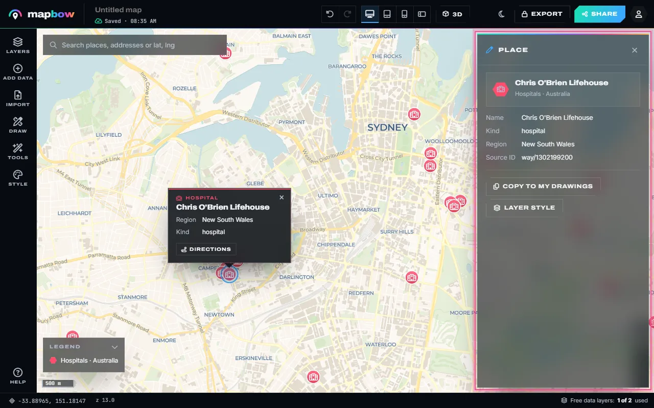
Places can be points (a café) or areas (a park, an airport, a campus). Many datasets store area-type places as a single representative point for simplicity, while boundary datasets keep the full outline.
POI data vs. boundary data
- POI (point) data answers "where are the things?" – for example every pharmacy in a country.
- Boundary (polygon) data answers "what area is this?" – for example states, counties, postcode areas or national parks.
The real insight usually comes from combining them: how many pharmacies per postcode, which suburbs have no supermarket, which parks have a playground.
How businesses use POI data
- Site selection: where to open a store, clinic or charger – near demand, away from competitors.
- Market sizing: count target businesses (e.g. restaurants for a food-supply company) by region.
- Sales territories and lead lists: balance territories by the number of prospects (territory guide).
- Real estate: show schools, transport and amenities around a property.
- Logistics and delivery: plan coverage and depots.
- Travel and tourism: maps of attractions, hotels and museums.
- Public sector and research: access to hospitals, schools, defibrillators or public toilets.
Quality: what to watch for
No POI dataset is perfect. Before relying on one, consider:
- Coverage – completeness varies by country, region and category. Cities are usually better covered than remote areas.
- Freshness – businesses open and close constantly. Check how often the data is refreshed.
- Attribute completeness – names and locations are near-universal; phone numbers and hours are patchier.
- Category definitions – does "clinics" include dentists? Does "hotels" include motels? Read the definitions.
- Duplicates – the same place recorded twice (for example as a point and as a building) inflates counts.
- Licensing – can you use it commercially, publish it, or resell it? What attribution is required?
How to get POI data by country with mapbow
mapbow includes ready-made POI and boundary layers for 199 countries and territories, across 109 layer types – 41,741,034 features in total, refreshed regularly and de-duplicated. Places are compiled from OpenStreetMap and boundaries from geoBoundaries, with attribution kept on every map and export.
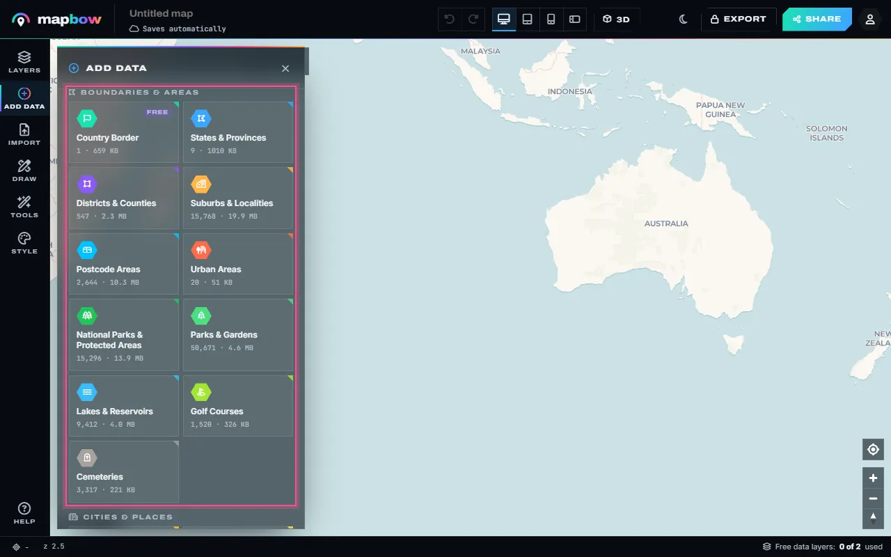
In the studio, the Add data panel is the catalogue: pick a country and every POI and boundary layer it has is listed by category, with its count.
- Browse the catalogue. Start at map data by country, or see a single type worldwide, such as EV charging stations.
- Check the numbers. Each country page shows how many places each layer contains and how they split by state or region.
- Add it to a map. Open the studio, choose Add data, pick the country and click the layer. Big layers can be loaded for the whole country or just one region.
- Explore and analyse. Style it, cluster it or show it as a heat map. Open the attribute table to search and sort every record, filter it (for example, only places where "opening hours" has a value), see statistics, count places per region with Count in areas, or group them into Hex bins (filter and analyse guide).
- Export if you need the raw data. With any purchase, export to CSV, GeoJSON, Shapefile, KML, KMZ, GPX, Esri JSON or a QGIS project.
Each map can use two data layers free. Extra layers are $5 each – once, forever, reusable in every map – or $29 for every layer in one country. See pricing and the data licence.
Common POI categories
| Group | Examples |
|---|---|
| Food & drink | Restaurants, cafes, bars & pubs, fast food |
| Health | Hospitals, clinics, pharmacies, dentists |
| Education | Schools, universities, libraries |
| Shopping | Supermarkets, shopping centres, convenience stores |
| Transport | Fuel stations, EV chargers, train stations, airports |
| Tourism | Attractions, museums, hotels, viewpoints |
| Public services | Police, fire stations, post offices, toilets |
A quick analysis example
Suppose you are choosing where to open a new pharmacy. Add the pharmacies layer and the suburbs & localities layer for your city, and run Tools › Count in areas to count pharmacies per suburb – each suburb is coloured and labelled by its count. Then add clinics – pharmacies often do best near doctors. Suburbs with several clinics but few pharmacies are your shortlist. Use Tools › Radius & rings to draw a 1 km circle around each candidate site to sanity-check walking-distance competition.
Frequently asked questions
What does POI stand for?
Point of interest – any place someone may want to find, visit or analyse, such as a shop, hospital, park or landmark.
Is POI data free?
Some open POI data is free but takes work to extract and clean. In mapbow you can use two built-in layers per map free and buy more for $5 each, or $29 for every layer in a country.
Can I download a list of POIs as a spreadsheet?
Yes. After any purchase you can export layers to CSV (or GeoJSON, Shapefile and more) with names, coordinates and available details. Before buying, you can browse every record in the studio's attribute table.
How accurate is POI data?
Locations are generally accurate to a few metres in well-mapped areas; completeness varies by country and category, so spot-check for critical uses.
What is the difference between POI data and geocoding?
Geocoding turns an address you already have into coordinates. POI data gives you places you didn't have – every pharmacy in a region, for example.