How to Draw a Radius on a Map
Draw an accurate radius circle on a map in miles or kilometres, add several rings, see what is inside, and share or embed the map. Step-by-step, free.
Updated · by the mapbow team
A radius map shows everything within a set distance of a point: a 10 km delivery zone, a 50 mile drive from a venue, a 500 m walk from a train station. It is one of the most searched-for map tasks because it answers such practical questions. Here is how to draw one properly – and how to make it actually useful by seeing what's inside.
Drawing a radius, step by step
- Open the radius tool. In the studio open Tools and choose Radius & rings (or go straight to the radius map tool). A card appears at the top of the map.
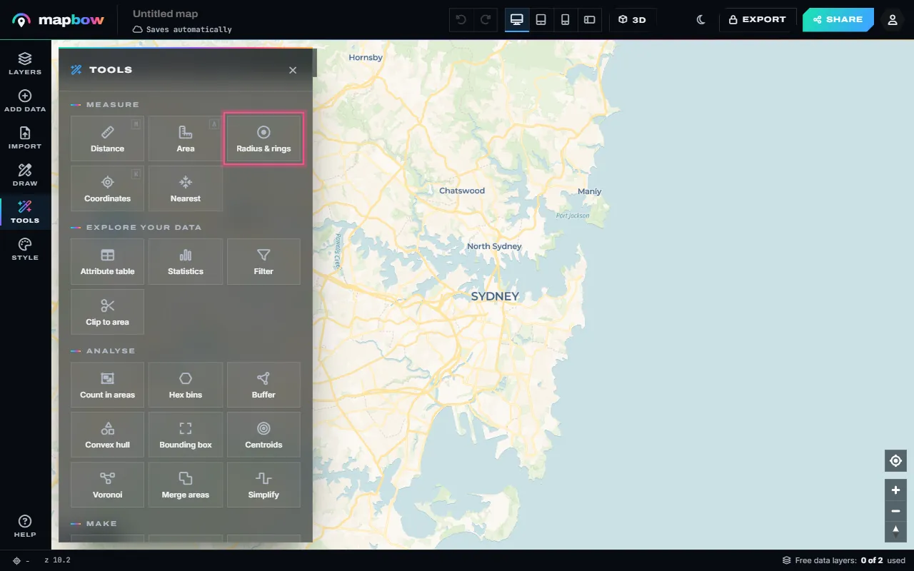
Step 1 Tools › Radius & rings. - Set the distance. Type the radius and pick kilometres, miles, metres or nautical miles. For rings at several distances type them all in the Rings box, separated by commas - for example
2, 5, 10.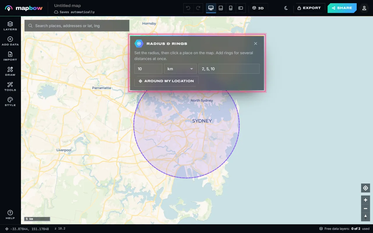
Step 2 A 10 km radius with rings at 2, 5 and 10 km. The circle follows the mouse until you click. - Click the centre. Click the place the distance is measured from - or search an address first, or press Around my location. The rings are drawn as true geodesic circles, each with its own colour and a label, plus a centre pin.
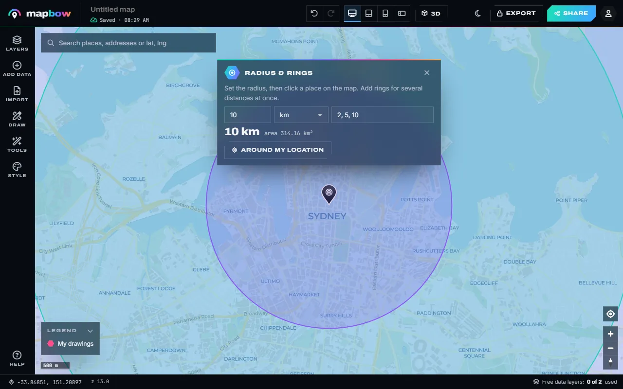
Step 3 Rings at 2, 5 and 10 km around Sydney's CBD. - See what is inside. Add a layer - here cafés - then open Tools › Count in areas. Choose your rings as the areas and the cafés as the points.
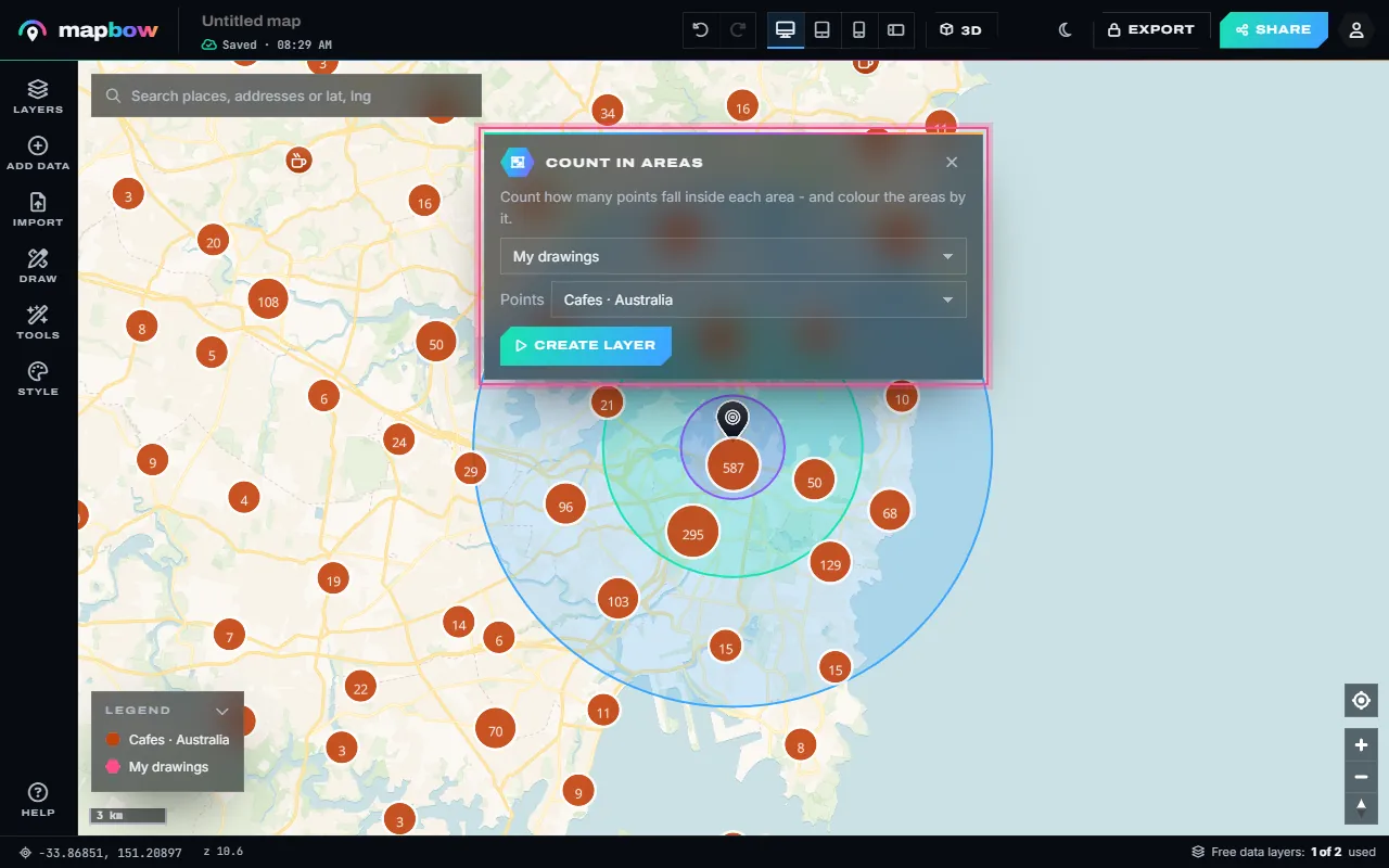
Step 4 Count in areas: how many cafés fall in each ring. - Read the counts. A new layer colours each ring by how many places it holds and labels it with the count. Click a ring for its popup, or open the table for the numbers.
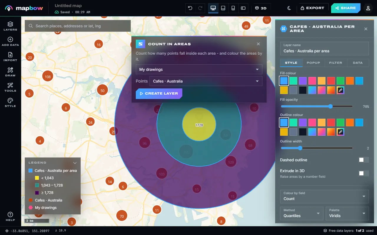
Step 5 Each ring coloured and labelled by its café count.
The card also shows the area of the circle once it is placed. The circles go into your drawing layer, so you can click one to name it ("Free delivery – 8 km"), change its colour and fill, or type a new distance in its Radius field in the inspector – the circle redraws around the same centre. The tool stays on, so you can keep clicking to place more circles around other points; press Esc when you are done.
Why circles look oval on some maps
Web maps use the Web Mercator projection, which stretches shapes as you move away from the equator. mapbow draws geodesic circles – every point on the edge is the same true distance from the centre on the earth's surface. Near the poles that circle looks taller than it is wide on a flat map. That is correct: it is the map that is distorted, not the circle. Tools that draw a "perfect" on-screen circle are actually wrong at higher latitudes.
See what's inside the radius
The real value of a radius map comes from what it contains. Two quick ways:
Use your own data
Import your customer or site list (CSV or Excel import), then run Tools › Count in areas with your circles as the areas and your list as the points. You get a new layer with the count for each circle, and the attribute table lists the numbers. To see the matching rows themselves, use the layer's Filter tab and Clip to an area › Use a drawn area.
Use a ready-made layer
Add a data layer for the country – schools, hospitals, supermarkets, restaurants, towns – and count what falls inside. Each map can use two data layers free; your drawings and imports never use a slot.
| Question | Radius | Layer to add |
|---|---|---|
| How many competitors are near my new shop? | 2–5 km | Cafes, restaurants, or your sector |
| Which schools are within walking distance of this house? | 1–1.5 km | Schools |
| Which towns can we reach within an hour's drive? | 60–80 km | Cities & towns |
| Is there a hospital close to the event? | 10 km | Hospitals |
| Where should the next EV charger go? | 20–50 km | EV charging stations |
Radius vs. buffer
A radius is a circle around a point. A buffer is the same idea around any shape: a 500 m corridor along a road, a 2 km band around a coastline, or a zone around a whole suburb. In the studio, open Tools › Buffer, choose a layer (or the selected feature) and a distance, and the zone is created as a new layer.
Real-world radius map ideas
- Delivery zones with tiered fees: 0–5 km free, 5–10 km $5, 10–15 km $10.
- Service areas for plumbers, cleaners and mobile mechanics.
- Catchments for a new gym, cafe or clinic.
- Safety zones for drones, blasting or events.
- Travel planning – everything within a day trip of your base.
Sharing your radius map
Press Share to get a link or embed code – ideal for a "Do we deliver to you?" page. Customers can search their own address and see whether they are inside. You can also embed it on your website, and export the circles as KML, GeoJSON or Shapefile with any purchase.
Tiered radius maps
A single circle answers "in or out?". Several circles around the same centre answer "how far?". Concentric rings are ideal for delivery pricing, travel-time estimates and catchment studies.
- Type all the distances at once. In Radius & rings, enter the rings as a list, for example
5, 10, 20, and pick the unit. - Click the centre. All the rings are drawn around that one point, each in its own colour and named by its distance.
- Adjust the colours if you like. Click each ring and pick one colour in lighter and darker shades – darkest for the inner ring, lightest for the outer – with a low fill opacity so the basemap shows through.
- Label each ring with its distance and what it means ("Free delivery", "$5", "$10").
Several locations, one map
For a chain of stores, draw the same radius around each location and give the circles a shared style. Where circles overlap you can immediately see areas served by more than one store; gaps show where nobody is close. Import your store list first (plot locations), then keep the radius tool open and click each pin in turn. For a zone around every store in one go, use Tools › Buffer on the store layer.
Units and conversions
| Distance | Equals |
|---|---|
| 1 mile | 1.609 km |
| 1 kilometre | 0.621 miles |
| 1 nautical mile | 1.852 km |
| Walking 10 minutes | about 800 m |
| Cycling 15 minutes | about 4–5 km |
Accuracy tips
- Zoom in before placing the centre so it sits exactly on the address or building.
- Use satellite imagery to confirm the centre on rural properties.
- Remember that circles describe straight-line reach. For travel time, combine the radius with real routes using the route map maker.
Frequently asked questions
How do I draw a 10 mile radius on a map?
Open Tools › Radius & rings, type 10, choose miles and click the centre point. The circle is drawn at exactly 10 miles.
Can I draw a radius around an address?
Yes. Search for the address first, then click on it to place the circle's centre – or press Around my location.
Can I draw multiple radius circles?
Yes, as many as you like. Type several distances in the Rings box for rings around one point, or keep clicking to place circles around other points. Each can have its own colour and label.
How do I change the size of a circle I have drawn?
Click the circle and type a new distance in the Radius field in the inspector. It redraws around the same centre.
Can I find out what is inside the radius?
Yes. Add your own points or a data layer and use Tools › Count in areas to count them per circle.
Is it accurate?
Yes. Circles are geodesic, so the distance is true on the ground at any latitude.