The Best Free Map Makers Compared
Google My Maps, Felt, Scribble Maps, MapChart, Mapbox Studio, QGIS and mapbow compared: what each is best at, who it suits and where it falls short.
Updated · by the mapbow team
There is no single "best" map maker – there is the best one for your job. A wedding map, a sales territory plan, a printed colour-coded poster and a professional GIS analysis need very different tools. This comparison describes what each popular option is broadly known for, who it suits and where it is limited, so you can choose quickly. Features and pricing change often, so always check each product's current pricing and plan limits before you commit.
At a glance
| Tool | Type | Best known for | Learning curve |
|---|---|---|---|
| Google My Maps | Web app | Quick personal pin maps using Google's basemap | Very low |
| Felt | Web app | Collaborative, modern web mapping for teams | Low |
| Scribble Maps | Web app | Drawing and annotating on maps | Low |
| MapChart | Web app | Colour-coded country and state maps as images | Very low |
| Mapbox Studio | Web app / platform | Designing custom basemap styles for developers | Medium–high |
| QGIS | Desktop software | Full professional GIS analysis, free and open source | High |
| mapbow | Web app | Custom interactive maps with ready-made place and boundary data by country | Low |
Google My Maps
What it is: Google's free tool for creating custom maps on top of Google Maps, tied to your Google account.
- Strengths: familiar interface and basemap; easy pins, lines and shapes; CSV/KML import; sharing through Google Drive.
- Limitations: limited styling and basemap choice, per-layer and per-map limits on the amount of data, basic analysis, and no ready-made datasets to add.
- Choose it if: you want a simple personal map and already live in Google's ecosystem.
Felt
What it is: a modern, collaborative web mapping platform aimed at teams and organisations.
- Strengths: polished interface, real-time collaboration, good file support and presentation features.
- Limitations: geared towards teams and organisations; check current plan limits for your use.
- Choose it if: several people need to work on maps together inside an organisation.
Scribble Maps
What it is: a long-running web tool focused on drawing, annotating and sharing maps.
- Strengths: quick drawing, text and shapes; well suited to classrooms and simple planning.
- Limitations: more of a drawing tool than a data tool; advanced features sit in paid plans.
- Choose it if: you mainly need to sketch on a map.
MapChart
What it is: a popular website for making colour-coded maps of countries, states and regions, exported as images.
- Strengths: extremely simple click-to-colour workflow, many ready-made region maps, clean image output.
- Limitations: produces static images rather than interactive web maps; not designed for points, routes or analysis.
- Choose it if: you need a colour-coded image for a slide or social post.
Mapbox Studio
What it is: Mapbox's tool for designing custom map styles and tilesets, used mostly by developers building apps.
- Strengths: deep control over basemap design and a powerful developer platform.
- Limitations: aimed at developers; publishing usually means writing code, and usage is metered.
- Choose it if: you are building a product and want a fully custom-designed basemap.
QGIS
What it is: free, open-source desktop GIS software used by professionals worldwide.
- Strengths: enormously capable analysis, every file format, print layouts, plugins – and no cost.
- Limitations: steep learning curve, desktop install, and publishing interactive web maps needs extra steps.
- Choose it if: you need serious spatial analysis or cartography and have time to learn.
mapbow
What it is: a browser-based map maker that pairs easy drawing, importing and styling with ready-made place and boundary layers for 199 countries and territories.
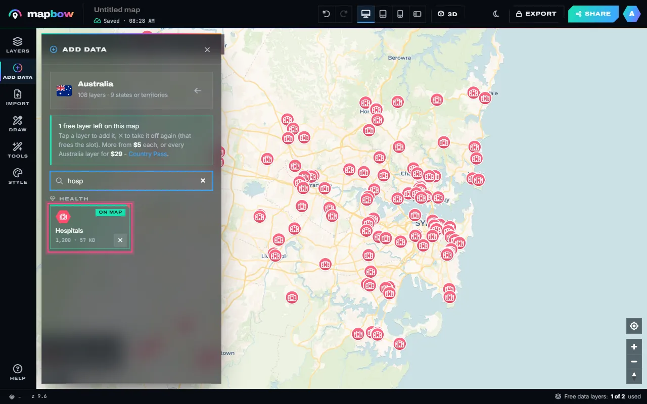
- Strengths: add layers such as hospitals, schools, restaurants, states or postcode areas in two clicks, from 109 layer types; free, unlimited imports of CSV, Excel (.xlsx), GeoJSON, KML, KMZ, GPX and zipped Shapefiles, pasted spreadsheet rows or a plain list of addresses; drawing tools for pins, lines, areas, circles, text and photo pins.
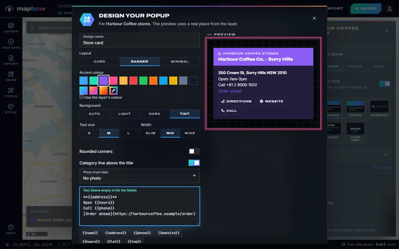
- Styling and popups: pins, badges, dots or heat maps; colour by field with categories, quantiles or natural breaks; labels, clustering and 3D extrusion; popup templates plus a popup designer with your own text, colours, photo and Directions, Website and Call buttons, saved to reuse on any map.
- Exploring and analysis: an attribute table (editable for your own data), filters, statistics, distance, area, radius & rings, nearest, count in areas, hex bins, buffer, Voronoi, merge areas, heat maps, territories and colour-by-region – all running in the browser.
- Presentation: 16 basemaps including satellite, topographic and blank; 3D terrain and buildings; a globe view; desktop, tablet and phone previews; free sharing (with a free account) and embedding that updates whenever you edit the map.
- Pricing model: free for unlimited maps with up to two built-in data layers per map; extra layers $5 each, once; a Country Pass is $29; any purchase unlocks exports to PNG, PDF, CSV, GeoJSON, KML, KMZ, GPX, Shapefile, Esri JSON, a QGIS project and a stand-alone web page. See pricing.
- Limitations: a web app, not a full desktop GIS – for heavy professional analysis, export to QGIS or ArcGIS. Built-in layers beyond the two free ones, and all exports, need a purchase. Shared and embedded maps show a small "Made with mapbow" badge.
- Choose it if: you want an interactive map with real-world data without hunting for datasets or learning GIS.
Which should you pick?
| Your job | Good fits |
|---|---|
| A few personal pins to share | Google My Maps, mapbow |
| Your own spreadsheet of places on an interactive map | mapbow, Google My Maps, Felt |
| Colour-coded image of countries for a slide | MapChart, mapbow (color map maker) |
| Interactive map embedded on a website | mapbow, Felt |
| Map of every hospital, school or EV charger in a country | mapbow (ready-made layers), QGIS (if you source the data yourself) |
| Team collaboration inside an organisation | Felt |
| Custom-designed basemap for an app | Mapbox Studio |
| Advanced spatial analysis | QGIS (optionally starting from a mapbow export) |
What to check before choosing any map maker
- Data limits – how many points or features per layer and per map?
- Data sources – do you have to find and clean data yourself?
- Exports – can you get your data back out in standard formats?
- Embedding – can you put the map on your website, and does it work on phones?
- Pricing model – one-off, per seat, per month or metered usage?
- Licensing – are you allowed to use the maps commercially?
How we compared them
Rather than score tools on a long feature checklist, we looked at the questions that actually decide whether a tool works for a job:
- Time to first useful map. How long from opening the tool to a map you would happily share? For a first-timer, anything over half an hour is a real cost.
- Where the data comes from. Most map makers assume you already have data. If you don't, the hours spent finding, downloading and cleaning it can dwarf the time spent mapping.
- Interactivity. Can viewers pan, zoom, tap for details and toggle layers – or is the output a static picture?
- Getting data out. Can you export to standard formats, or are you locked in?
- Cost model. Free, one-off, per seat, per month or metered by usage – and what happens when you outgrow the free tier.
Web map maker or desktop GIS?
The biggest decision is not which brand, but which category. Web map makers (Google My Maps, Felt, Scribble Maps, MapChart, mapbow) run in a browser, need no install, are quick to learn and are built for sharing. Desktop GIS (QGIS, ArcGIS Pro) is built for analysis: projections, geoprocessing, topology, large rasters and precise cartography. Many professionals use both – a web tool for quick maps and communication, desktop GIS for heavy analysis – moving data between them with GeoJSON or Shapefile.
Static images vs. interactive maps
A static image is perfect for print, slides and social posts – it looks identical everywhere. An interactive map is better on the web: people can zoom to their own street, tap a place for its phone number, or switch layers on and off. If you are unsure, make the interactive map first; most web tools can also export an image, while turning an image back into an interactive map is impossible.
Watch out for hidden limits
- Feature caps – limits on points per layer or layers per map can bite once a project grows.
- Branding – free embeds often carry a logo or badge; check whether that is acceptable on your site.
- Metered usage – developer platforms can bill by map loads, which is unpredictable if a map goes viral.
- Commercial use – some free tiers or basemaps restrict commercial use; read the terms.
- Data licences – if you add third-party data, check whether you may publish or resell it and what attribution is required.
Frequently asked questions
What is the easiest free map maker?
For simple pins, Google My Maps and mapbow are both very easy. For colour-coded country images, MapChart is very quick. For maps with ready-made data, mapbow is the fastest.
What is the best free GIS software?
QGIS is the leading free, open-source desktop GIS. It is powerful but takes time to learn.
Which map maker lets me embed maps on my website?
mapbow, Felt and Google My Maps all offer embedding; check each tool's current limits and branding rules.
Can I move my map between tools?
Usually, via standard formats such as GeoJSON, KML, CSV or Shapefile. See map file formats explained.